
Summary
In this lesson, students will explore how water behaves on various substrates (ground surfaces), what occurs during a flood, and the causes of flash floods. This lesson concluded with students designing and testing various floodplain models intended to mitigate the effects of flash floods. Acknowledgement: This lesson was written through a partnership with the Oklahoma Floodplain Management Association division of the Oklahoma Water Resource Board.
Essential Question(s)
What can scientists do to understand the factors involved in flash floods and how can the effects from flash floods be mitigated?
Snapshot
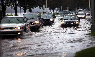
Engage
Students view an EAS (Emergency Alert System) flash flood warning and/or flash flood video clip and utilize a KWL chart to organize what they know about flash floods.
Explore
Students use clay models and graph paper to investigate watersheds and explore how water behaves in a general watershed. Students also investigate how water behaves on various substrates.
Explain
Students participate in collaborative group discussion to summarize the findings from the watershed and substrate experiment.
Extend
Students investigate specific watersheds containing different substrates and how these would relate to flash floods.
Evaluate
Students design and create a community watershed model to represent an "ideal" community design to mitigate flooding. Students also create a presentation showcasing their model addressing flash flooding using the theme "Turn Around Don’t Drown."
Materials
Flash Flood Warning Clip(s) https://www.youtube.com/watch?v=7V-2Ny6NGYI
Flash Flood Video Clips—Could Use Clips such as the following or search Oklahoma Flash Flood
Modeling clay
Aerial photographs of watersheds over different time periods
Sample photos included others can be found by searching and/or the links below:
Transparent grid paper (you can photocopy graph paper onto transparencies)
Dry erase markers
Water
Food Coloring
Eyedropper
Wax paper
Blue string
Red string
Scissors
Rectangular plastic food storage container with hole on short end for drainage
Wooden blocks
Watering can
100 mL graduated cylinder
Sponges
Flooring tiles
Plastic cups
Hydrology Student Handout (attached)
Poster or Butcher paper
Markers, crayons, or colored pencils
Rubric (Included)
Engage
Begin by playing the flash flood warning for the students.
Provide the students with the KWL chart (See K20 Tools Sheet). Have the students fill out the first two columns of the chart with information that they currently know (K) and information they would like to know (W) concerning floods and floodplains.

Explore
Investigation #1
Begin by providing each student group a ball of modeling clay atop a sheet of wax paper or paper plate. Direct the students to create an island using the modeling clay. The island should not be flat - it should have hills or peaks and valleys.
Provide each student group with an eyedropper and a container of water. Direct the students to drop water on different locations on their island and observe the path of the water as it runs off of the island. (Note: If the water pools in one location, direct students to add more water to the pool until it runs off.)
Next, give each group of students a spool of blue string and a pair of scissors. The blue string will represent the island’s streams. Direct students to push the blue string into the clay at the locations where the water runs off the island. Finally, direct each group of students to outline the boundaries of the watershed areas with the green or red string.
Have students do a Gallery Walk. Ask students to walk around the room and make observations of the other groups’ watershed model noting similarities and differences.

Investigation #2
Give each group of students a copy of the Hydrology Data sheet to record their data (attached to end of lesson).
Provide each student group with a rectangular food storage container ("drainage" container), a watering can, a 100 mL graduated cylinder, a plastic cup, a sponge, and flooring tiles.
Direct students to prop up the short end of the container (the end without the hole) using wooden blocks.
Instruct students to place several tiles in the bottom ¼ of the drainage container, and then pour 100 mL of water into the watering can while holding the can over the elevated end of the drainage container.
Have a second student should collect the drained water in a cup, while a third student times the water collection.
Have students collect the water for 30 seconds and capture the remaining water in a separate container, then discard it. Direct the students to record the amount of water collected on a data table.
Direct students to repeat the investigation using sponges instead of tiles.
Finally, direct students to repeat the investigation at least three times using both tiles and sponges, varying the ratio of tiles to sponges with each trial. For instance, have students could test a ratio of 75% tile to 25% sponge, or 50% tile to 50% sponge. A sample picture of a 75% tile to 25% sponge set up is shown below.

Explain
Direct students to graph the data collected during investigation #2 using the included data table.
At this point you may need to define pervious and impervious for the class.
Pervious - allowing water to pass through; permeable.
Impervious - not allowing fluid to pass through; impermeable.
Lead a discussion with students in which they analyze the impact of different substrates on water runoff, relate that to the effect of real-world land surface substrates on water runoff, and explain how flash floods occur and can be prevented. Sample questions and responses include:
How do the different substrates affect water run off? (Probe to have them cite evidence from their experiment.)
Which real-world land surfaces would result in greater run off? Which would result in less runoff? (Probe to have them cite evidence from their experiment.)
How do surfaces that are already saturated affect runoff? (Probe to have them cite evidence from their experiment.)
How do surfaces that are extremely dry affect runoff? (Probe to have them cite evidence from their experiment.)
How do surface types contribute to, or mitigate, flash flooding? (Probe to have them cite evidence from their experiment.)
Extend
Provide each group with a transparency and three different colors of dry erase markers.
Give each group an aerial photo map of one of the regions (maps can be local maps or you can use maps from the following websites:
Ask the students to look at the picture, give the students time to study it, then ask them what they see when looking at the photo.
After the students have shared with the class, have their group create 3-4 categories to classify the land use. Ex. Wild, Agriculture/Farming, City/Municipal, Forest, etc..
Give each category a color (Ex. - Agriculture = red, Municipal = Blue, Forest = Green)
Instruct students to place the grid transparency over the map and to color in the squares according to the land use. Have the students do this for the other maps as well so they can compare how the land use has changed over time. See examples on next page:


•Have students calculate the ratio of land usage for each time period.
EX: 1936
Forest 100/391=26%
Undeveloped/Farm 278/391=71%
Developed/Municipal 13/391=3%
Discuss the results with the students. Use the following questions to guide the discussion:
When looking at the watershed over time what observations can you make?
What type of land would you consider as "livable space"? Ask them to explain why they decided this.
What type of surfaces would be included in a developed "livable space"?
Have each group write a GIST statement responding to the following prompt: Based on how land use has changed how would this change in land use and surface type effect the frequency of flash flood events?
Evaluate
Provide each group with a copy of the rubric that will be used to grade their project.
Provide each group of students with a large piece of butcher paper or poster paper.
Explain that their community model can resemble your local community (students can use what they know as a starting point for their model); however the goal is to reduce or mitigate the effects of flash flooding.
Direct students to create a community watershed model. Inform the students that their goal is to create a model of community development that reduces and/or mitigates the risk of flooding.
Each community model must include the following:
A business districtoResidential neighborhoods
Roads and highways
Public services (hospital, library, post office, police, fire)
Parks and Recreation
Instruct students to label all components of the model, including drainage ditches or retention ponds if included in the model.
Ask students to create a 3-5 minute video or slideshow with audio that communicates to the general public in an informative, memorable, and creative way, lessons learned and reasoning used to maximize livable space in your community model and minimize the resulting runoff caused by development. The phrase "Turn Around, Don’t Drown" must be used at least once for text and once as audio to emphasize understanding of flood safety and the dangers associated with floodwaters. A rubric for evaluating the presentations and model is included.
Ask students to complete an exit ticket out the door by writing a summary statement that answers the essential question: What can scientists do to understand the factors involved in flash floods and how can the effects from flash floods be mitigated.
Resources
Flash Flood Warning vs. Watch - http://www.youtube.com/watch?v=ToobzfkcB3Y
National Weather Service Stream Hydrograph real time data - http://www.srh.noaa.gov/abrfc/
3D Floodplain model and video example - https://www.wardsci.com/store/catalog/product.jsp?catalog_number=805770
K20 Center. (n.d.). Gallery Walk/Carousel. Strategies. https://learn.k20center.ou.edu/strategy/118
