

Summary
In this lesson, students are introduced to maps and globes as models of the Earth. They will begin this lesson by thinking and sharing with their classmates what they already know about globes and maps. Each student will explore a tiled map of the Hawaiian Islands (or another state or region) to find out how they might find certain areas on the map. Watching a video clip about latitude and longitude, students will work together to draw lines on a globe and learn the principles of latitude and longitude. At the end of the lesson, student pairs will practice identifying places on a gridded map by giving each other coordinate pairs.
Essential Question(s)
Why is understanding maps and globes important? How can longitude and latitude help me know where I live?
Snapshot
Engage
Students participate in a Tell Me Everything activity as they look at a globe or map of the world. Students record their ideas on sticky notes, shared with the class, and added to the KNOW column of a KWL chart. Student questions may also be recorded on the chart under the WHAT column.
Explore
Students are given a tiled map of the Hawaiian Islands or a different state or region. This map is labeled with numbers and letters on the outside of each tile. Students work with Elbow Partners to name a location on the map using only the numbers and letters on the outside. Students show and share their findings with the class and add these strategies to the KWL chart.
Explain
The class watches an age-appropriate video clip about the purpose of latitude and longitude lines on maps and globes. While the class is watching the video, latitude and longitudinal lines are drawn on a class globe or map.
Extend
Students play a game of Battleship. Working in pairs, students play using lines of latitude and longitude as well as specific location points to target their partner’s battleships.
Evaluate
Students do a follow-up Tell Me Everything activity to write, draw, and label what they have learned about finding locations and the imaginary lines of latitude and longitude on maps. In an additional evaluation, students locate a Hawaiian Island, or another location, on a map by using latitude and longitude, recording the coordinates, and explaining their process.
Materials
A classroom globe
Classroom world or USA map(s)
Large sticky notes (1 per student)
Explore the Map Recording Sheet (1 per student; attached)
Maps—Longitude and Latitude (1 per student; attached)
Tiled and Untiled Maps of Hawaii (1 per student; attached)
Other state or regional maps (optional)
Lesson Slides (attached)
Chart paper or whiteboard/projector space
Battleship (physical, online, or homemade copies)
Orange and crayons/markers (optional; one per student)
Engage
30 Minute(s)
Display slide 3 from the attached Lesson Slides and identify the essential questions:
Why is understanding maps and globes important?
How can longitude and latitude help me know where I live?
Display slide 4 and briefly explain the lesson objectives:
Describe the purpose and features of maps and globes.
Make connections between locating specific places on maps, lines, and latitudes.
Display slide 5 and show students a map or globe. This may include the pictures on the slide, or a globe, wall map, or digital map in your classroom. Give each student a large sticky note and have them write down things they already know about maps or globes.
Display slide 6. Introduce the Tell Me Everything strategy. Have students use this strategy to share the contents of their sticky notes with an Elbow Partner.
Have each pair share with the whole class.
Display slide 7, and show students the KWL chart on the slide. Ask pairs to walk up and stick their sticky notes into the KNOW column of your classroom’s KWL chart. Note that students will use and reference this chart throughout the unit.
Display slide 8. Have students brainstorm about what they want to learn about the map or globe. Record student questions—or things they wonder about—in the WANT portion of the chart.
As you proceed in the lesson, use these student-generated questions and topics to guide student research. Add additional questions throughout the lesson.
Explore
Display slide 9. Give each student a copy of the prepared tiled map of Hawaii (or another region). Additionally, hand each student a copy of the attached Explore the Map Recording Sheet.
Invite students to explore with their Elbow Partners ways to name locations on the map (either a location you have determined or a location of their choice) using only the numbers and letters on the outside. Have students use their Map Recording Sheets to write down their strategies for finding interesting places. Have students show their maps and share these findings with the class. Additionally, add these strategies to the LEARN column of the KWL Chart. Have students show and share their findings with the class. Add these strategies to the LEARN column as well.
Explain
Display slide 10. Use one or both of the videos linked below and on the slide to explain latitude and longitude.
As you watch the video(s) with the students, pause at various times and draw the lines on a physical globe as they are described.
Display slide 11. Ask students to help label the basic parts of the globe. Instruct them to listen carefully to the videos, read, and write down vocabulary words related to maps and globes:
Globe
Map
Locate
Equator
North and South Pole
Latitude Lines
Longitude Lines
Imaginary
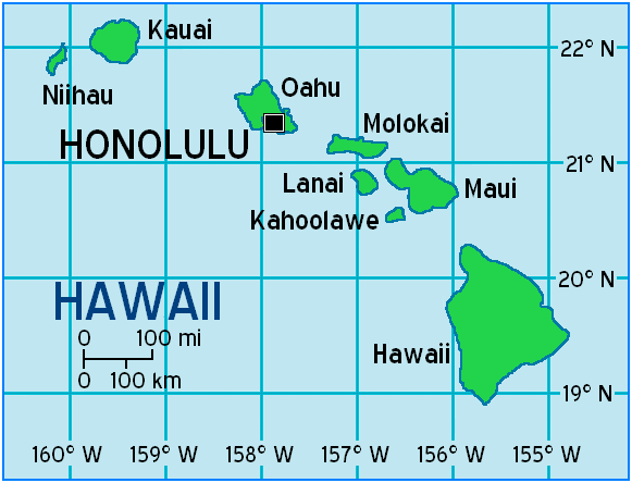
Display slide 12. Once students are familiar with the relevant vocabulary words, pass out one map from the attached Maps—Longitude and Latitude to each student. These maps show latitude and longitude lines, and they include the Hawaiian Islands, Oklahoma, and the United States. You can use a map of a different region if preferred.
Show students how to find a location on this new map with the numbers on the top and right side. Have students work with their partners as they test each other on finding interesting or familiar places on the map. Monitor student pairs to ensure that they can explain to each other how they are identifying the places they have selected. Ask guiding questions to support student inquiry.
Display slide 13. Revisit the essential questions and check current understanding: Why is having an understanding of maps and globes important? How can longitude and latitude help me know where I live?
Display slide 14. Close this part of the lesson by revisiting the KWL chart and have students help you add to the LEARNED column. This is also a good time to check with students about additional questions they may want to add to the chart. The teacher may need to add to the chart after the discussion of the essential questions.
Tech Integration
Extend
Display slide 15. Have students work in pairs to play Battleship. Instruct them to think about lines of latitude and longitude as well as specific location points to target their partner’s battleships.
While students play, visit with groups and ask students: “How is the Battleship game like finding places on the globe or a map?”
After meeting with each group and giving students adequate playing time, have a whole class discussion to help them make connections. You may want to return to the original tiled map from the explore section and have them find additional locations for more practice or give them a map of a new area to find locations.
Evaluate
Display slide 16. At the beginning of the lesson, you introduced the Tell me Everything strategy as a formative assessment to guide your teaching and to help students start the KWL chart populating it with what they already knew.
Now, hand each student a copy of the attached Tell Me Everything handout. Have them use the same strategy to write, draw, and label what they have learned. This is an open-ended activity useful in determining whether or not the students can make connections between finding locations and the imaginary lines of latitude and longitude on maps. Keep the KWL chart out in the classroom as a resource.
As students work, use the following guidelines to evaluate:
Listen and monitor Elbow Partner conversations and whole-group discussions throughout the lesson.
Take anecdotal notes about student participation.
Determine whether or not students can locate specific points on a map.
Determine whether or not students use some or all of the introduced vocabulary (latitude, longitude, map, etc.).
If you wish, add an additional evaluation by asking students to locate a Hawaiian Island or other location on a map by using latitude and longitude. Have students record the coordinates for the location and explain how they found it.
Resources
AghettoDIY. (2011, March 7). Homemade Battleship game. [Video]. YouTube. https://www.youtube.com/watch?v=GXsZ7b9U9-U
Jensen, Andy. (2010, January 14). Latitude and longitude. [Video]. YouTube. https://www.youtube.com/watch?v=swKBi6hHHMA
K20 Center. (n.d.). Elbow Partners. Strategies. https://learn.k20center.ou.edu/strategy/116
K20 Center. (n.d.). Geoboard. Tech Tools. https://learn.k20center.ou.edu/tech-tool/627
K20 Center. (n.d.). KWHL Graphic Organizer. Strategies. https://learn.k20center.ou.edu/strategy/127
K20 Center. (n.d.). Tell Me Everything. Strategies. https://learn.k20center.ou.edu/strategy/107
Kronemberger, Isabella. (n.d.). World globe. [Photograph]. Unsplash. https://unsplash.com/s/photos/world-globe?utm_source=unsplash&utm_medium=referral&utm_content=creditCopyText
Map of Hawaiian Islands. (n.d.). [Map with latitude and longitude lines]. https://userscontent2.emaze.com/images/64cdee91-94a3-4282-9845-c528d0402f57/ae50de9fb4f71c36cbee2af47ef3292b.png
Maps of World. (2017, September 6). Hawaii latitude and longitude map. [Image]. https://www.mapsofworld.com/usa/states/hawaii/lat-long.html
Maps of World. (n.d.). Hawaii latitude longitude map. [Image]. https://www.google.com/imgres?imgurl=https://i.pinimg.com/originals/ba/c8/85/bac8854f50b497d4c624dc42fbd06eda.jpg&imgrefurl=https://www.pinterest.com/pin/173177548152426858/&tbnid=HmlRSh6sL7h_NM&vet=1&docid=dzYPbinkdSollM&w=800&h=721&itg=1&hl=en&source=sh/x/im
Restom, Donne. (2015, October 22). How to play battleships. kidspot. [Article]. https://www.kidspot.com.au/things-to-do/activity-articles/how-to-play-battleships/news-story/d12ea620a56f61a3597d2ef67d5ce4fd
Roble Education. (2015, September 2). Dr. Nagler’s Laboratory: Longitude and latitude. [Video]. YouTube. https://www.youtube.com/watch?v=cTrsvGytGG0